Project Name:山西丹河滨水景观及河岸公园景观规划设计方案 Location:山西丹河
Year:2013 - today
Program & size: landscape design
Design team:Atelier Loos van Vliet, Arktree, Witteveen en Bos
Project Type:滨水滨江景观设计 滨水公园景观设计 河道综合整治 河流景观设计 Key words:waterfront area planning, regional development planning, planning, agricultural tourism, eco-park landscape planning and landscape planning and conservation, 滨水规划 滨水景观 公共空间 河道景观 生态修复 公共滨水景观 滨水景观 滨河公园 生态水系规划 旅游度假区规划 保护地规划 河岸规划 滨江公园景观规划设计 公共滨水景观设计 All photos :©niekroozen Text译:zoscape |
山西丹河滨水景观及河岸公园景观规划设计方案
山西丹河项目背景:
丹河,黄河北岸支流沁河的支流,古称源泽水、泫水、丹水等。主要发源于山西省高平市赵庄丹朱岭。流经晋城市区、晋城泽州县和河南省焦作市、沁阳市。丹河是晋城境内的第二大河,“晋城”在隋朝开皇十八年,别称为丹川县,名称即取自丹河,被誉为晋城和焦作人民的“母亲河”,丹河主要支流有巴公河、塔水河、白水河、石盆河等。
丹河水资源较为丰富,干流上建有任庄、焦河、青天河等水库,为农业工业和生活提供了丰富水源。丹河晋豫交界处为太行山边缘,多为峡谷,河南省开发有青天河、沁阳丹河峡谷等旅游区。
 山西丹河滨水景观及河岸公园景观规划设计方案 山西丹河滨水景观及河岸公园景观规划设计方案 山西丹河滨水景观及河岸公园景观规划设计方案 山西丹河滨水景观及河岸公园景观规划设计方案
丹河干流始于高平市赵庄丹朱岭,故名(也说为战国长平之战时,秦坑杀赵卒40万,河水被血染红而称丹河)。流经晋城市郊区(泽州县)鲁村、北义城、高都、水东、金村、柳树口、南河西等乡镇,入河南省。境内长121.5公里。有众多支流汇入。河床宽约100米,流域面积2949平方公里
山西丹河滨水景观及河岸公园景观规划设计方案
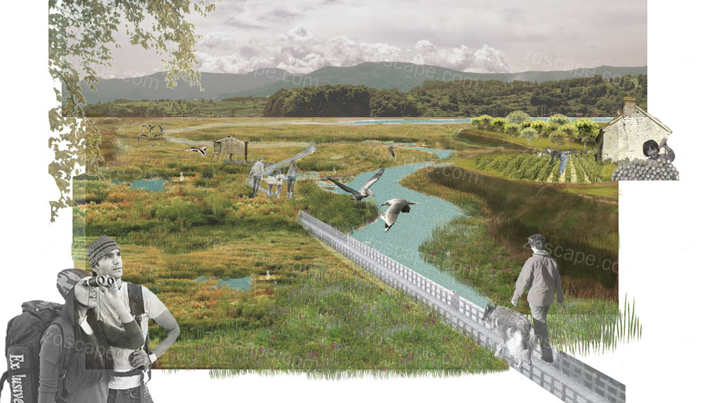
山西晋城的丹河是一条由于矿业开发被污染的河流。设计的任务包括制定一项战略来净化河流和河床,并设计一个和文化历史相结合的河流公园。丹河对候鸟的迁徙有很大的影响。从而候鸟迁徙这一活动成为整个设计的灵感来源。
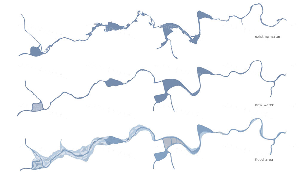
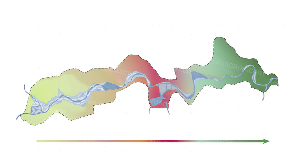
公园从南到北有不同的环境氛围,从北面自然的湿地向中部突显文化的城市公园过渡,直至南面生态脆弱和可达性低的区域。特色花园散布在整个公园里,全部种植本地植被,如莲花园和厥园。另一个特别的花园记载了这里矿石开采的遗迹。河流的形状被重新设计,给公园带来更大的多样性。比如一个区域有众多自然的岛屿,一个区域有垂直的河堤,还有一个区域有瀑布。河床被重新设计,被扩大的河床在将来可以容纳更多河水。景观规划设计师还建议修建水坝, 可以在干旱的夏季给特定区域提供水源。
 山西丹河滨水景观及河岸公园景观规划设计方案 山西丹河滨水景观及河岸公园景观规划设计方案
 山西丹河滨水景观及河岸公园景观规划设计方案 山西丹河滨水景观及河岸公园景观规划设计方案
河流净化战略包括很多不同的步骤。首先,净化河的上中游,其次是清理河床和河岸。然后是加宽河床并建设岛屿,让受污染的颗粒在上游沉淀。此外在河岸上栽种植被,进一步减少污染并防止水土流失,并构建不同的沉降台阶,让余下的受污染颗粒沉淀。一个大型的芦苇荡漾的人工湿地在公园中心,进一步净化河水,让河水水质最后达到可以游泳的程度。
Dan River is a mining development due to the polluted rivers. Design tasks include the development of a strategy to purify river and riverbed, and design a combination of history and culture of the river park. Dan River has a great impact on migratory birds. Thereby migratory activities become a source of inspiration throughout the design.
山西丹河滨水景观及河岸公园景观规划设计方案
Park from the south to the north has a different ambience, from the north of natural wetlands to highlight the cultural transition to the middle of the city park until the south ecological vulnerability and accessibility of low areas. Features gardens scattered throughout the park, all planting native vegetation, such as the Lotus Garden and dedication Park. Another special garden here described ore mining remains. The shape of the river has been redesigned to bring greater diversity to the park. For example, a region has many natural islands, a region with vertical embankments, as well as an area with waterfalls. Riverbed has been redesigned to be expanded in the future to accommodate more riverbed river. Landscape Planning and designers also proposed building a dam, can provide water to a specific area in the dry summer months.
山西丹河滨水景观及河岸公园景观规划设计方案
River cleanup strategy includes many different steps. First, clean on the middle reaches of the river, followed by cleaning up the riverbed and riverbanks. Then widen the riverbed and building the island, so that the particles of contaminated sediment in the upstream. Also planted in the riparian vegetation to further reduce pollution and to prevent soil erosion, sedimentation and build a different level, so that the rest of the contaminated particles to settle. A large wetland reed waves in the center of the park, to further purify the water, so the water quality to the extent that you can finally swim.
|