|
滦河上游生态景观规划设计
Landscape Planning of Luan He River Plant Nursery
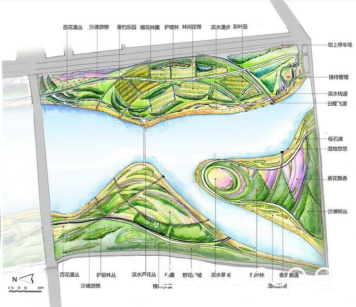
滨河景观规划总平面图

滨河景观带

景观苗圃节点图

滨河生态带效果图

I. Project Description
Qian'an Luan River is the largest river crossing in Qian'an segment mostly sandy riverbed pebbles, river narrowest point 150 meters, 5200 meters at its widest point. The design area is located in the city suburb, water sources upstream, an area of about 133 hectares, about 4 km.
Going upstream status barren, mostly vacant, flat terrain, soil better; east side gas station and villages; south side of the living area and Huangtai Lake Scenic Area. There are two venues bridge, connecting the east and west sides the river's main traffic routes; two dams and a diffuse water bridge, the whole waters divided into three parts.
Second, the design ideas
Design ideas to consider along the horizontal and vertical structure, combining short-term and long-term planning and positioning, thus saving cost and with minimal start-up capital to create the greatest landscape.
1. A building located: Southern Country Park, East Coast and West Coast nursery riverside landscape with the combination;
Main content:
(A) forest tree belt and mound topography enclosed planting skeleton form, the initial formation of riparian landscape style; (2) the establishment of basic roads and irrigation systems; (3) forest nursery seedling cultivation, the formation of a certain scale economies .
2. Two transitional phases: Country Park
Main content:
(A) the use of riparian pebble beach activities programs, and increase services to satisfy the public demand for leisure sports and excursions; (2) local nursery reserved for scientific research, introduction and domestication.
3. Forward Construction Positioning: City comprehensive park.
Main content: increased service facilities, improve the city's comprehensive park features.
Third, the overall structure
Horizontal structure:
Luan River from the river to the dam transverse structure can be divided into three levels:
(1) Riverside Band: use of the river, along the river pebbles and sand, the design of aquatic plants, desert plants, wetland plants and trees to create a riverside Mission style, node opens the flood events venue.
(2) Nursery band: the forest and tree groups (large seedlings, speed seedlings) formed landscape skeleton with internal plant seedlings, slow-growing species, wildflowers together form views woodlots;
(3) dam protection zone: the transformation of vegetation on the east side of the dam (dam hard mainly sow flower, extensive management, to self-sow reproduction), the west side of the dam to create a green belt (slope formed flower + shelterbelts).
Vertical structure (a building)
Based rubber dams and Peng Li II Bridge is divided into three vertical sections:
(1) Nursery Landscape: Upstream segment good soil, conducive to plant growth, primarily as a nursery production base; and use the beach and riparian vegetation to create a style.
(2) riverside garden: poor soil conditions, suitable for beach activities to carry out the project; woodland area complemented by the production function.
(3) Country Park: poor soil is not conducive to plant growth, adjacent to residential areas, recreational facilities suitable for pooling arrangements and events venue.
设计思路
设计构思考虑沿河横向与纵向结构,近期与远期相结合进行规划定位,从而节省造价,利用最少的启动资金创造出最大的景观效果。
1.一期建设定位:南部郊野公园、东岸滨河景观带与西岸苗圃相结合;
主要内容:
(1)林木树带和土丘地形围合形成种植骨架,初步形成滨河景观风貌;(2)建立基本的道路系统和灌溉系统;(3)林间圃地培育苗木,形成一定规模的经济效益。
2.二期过渡阶段:郊野公园
主要内容:
(1)利用滨河卵石滩开展活动项目,增加服务设施,满足市民休憩运动以及游览需求;(2)局部保留苗圃进行科研、引种驯化。
3.远期建设定位:城市综合性公园。
主要内容:增加服务设施,完善城市综合公园的功能。
总体结构
横向结构:
从滦河河道至堤坝的横向结构可分为三个层次:
(1)滨河带:利用河流、河流沿岸的卵石和沙滩,设计水生植物、沙生植物、湿生植物以及树团营造滨河风貌,节点处开辟河滩活动场地。
(2)苗圃带:以林带和树团(大苗、速生苗)形成景观骨架,内部植以小苗、慢生树种、野花共同形成片林景色;
(3)堤坝防护带:对东侧堤坝进行植被改造(硬质堤坝为主,撒播草花,管理粗放,能自播繁衍),营造西侧堤坝绿化带(缓坡处形成草花+防护林带)。
|